
Proving You Were Actually There: How a Timestamped, Geotagged Photo Holds Up
GPS Map Camera: GeoTag Stamp prints location, time, and map data straight onto a photo - a look at how that kind of documentation actually gets used in real disputes, inspections, and fieldwork.
Key Takeaways
- GPS coordinates, address, date, time, altitude, compass direction, and weather all get stamped directly onto the photo, not just stored separately in EXIF data that can get stripped out.
- It's useful for contractors, real estate and property managers, delivery and field service workers, and inspectors who need a dated, location-anchored photo trail.
- A built-in QR scanner and customizable stamp templates (logo, notes, hashtags) round out the toolset for fieldwork and business documentation.
- It's a phone-stamped photo, not a legally certified survey record - treat it as strong supporting documentation, not a courtroom-grade guarantee.
Get this app
About this app
A plain photo proves what something looked like. It doesn't prove when it was taken, or where. That distinction sounds small until it matters - a landlord disputing when a leak started, an insurance adjuster questioning whether "before" and "after" photos are really from different days, a client asking a contractor to prove a delivery actually happened on-site. In all of those situations, the image itself is only half the evidence; the metadata sitting behind it is the other half.
That's the specific problem GPS Map Camera: GeoTag Stamp is built to solve, and it's worth looking at through that field-documentation lens rather than as a general photography app.
What actually gets stamped onto the photo
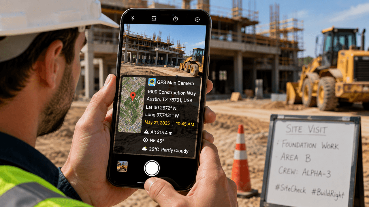
The app prints GPS coordinates, address, date, time, altitude, compass direction, and even weather conditions directly onto a photo at the moment it's captured, alongside a small embedded map for location context. Because that information is baked into the image itself - not just stored separately in EXIF data that can get stripped out when a photo is compressed, forwarded, or uploaded to social media - the timestamp and location stay visible and legible even after the photo has been shared several times over.
Where this kind of documentation earns its keep
- Contractors and construction crews: photographing site conditions before work starts, to have dated proof of pre-existing issues if a dispute comes up later
- Real estate and property management: logging a property's condition at move-in or move-out with a stamped, dated record instead of a plain photo with no context
- Delivery and field service: confirming a drop-off or job actually happened at the stated address and time
- Inspectors and surveyors: building a location-anchored photo trail across a site visit, with map view and Street View available for added context
None of this requires anything exotic - it's the same basic instinct as a handwritten log, just automated onto the photo itself instead of a separate notebook or spreadsheet.
A closer look at one common scenario: the insurance dispute
Take a fairly ordinary example: water damage in a rental unit. A tenant photographs the damage the day they notice it; the landlord claims it must have already existed at move-in. A plain photo doesn't settle that - both sides can argue about when it was actually taken. A stamped photo with a date, time, and GPS location baked directly into the image gives a much harder timeline to dispute, precisely because the information isn't sitting in metadata that's easy to question or that gets lost the moment the photo is compressed and texted to someone.
The map view options matter more than they might seem for this kind of documentation too. Satellite and hybrid views make it easy to confirm a photo was taken at the specific property or job site in question, rather than just trusting a set of coordinates on their own - useful context for anyone reviewing a stamped photo after the fact who wasn't there when it was taken. None of this is about catching anyone in a lie by default - most of the time, a stamped photo just settles an honest disagreement about timing faster than two people trying to remember which day something happened.
A few other practical tools bundled in
Beyond the stamp itself, the app includes normal, satellite, terrain, and hybrid map views plus Street View for extra location context, customizable stamp templates (logo, notes, hashtags for anyone documenting for a business or brand), and a built-in QR code scanner, which comes in handy during inspections or fieldwork where a lot of relevant information is already sitting behind a QR code.
The honest limit
A phone-stamped photo is useful supporting documentation - it's genuinely harder to dispute than a plain, unstamped image - but it isn't a substitute for professional survey equipment or legally certified records in contexts that specifically require them. Treat it as strong, convenient evidence for the everyday disputes and records most people actually deal with, not as a courtroom-grade guarantee. It's a modestly sized listing so far (4.0 stars, 125 reviews) with ads and in-app purchases, which is standard for the category.
The same basic instinct applies well beyond disputes, too. A stamped photo works just as well as a simple personal record - proof a repair was actually completed on a certain date, or documentation of a vehicle's condition before a road trip - situations where nobody's necessarily arguing yet, but where having a dated, located photo on hand avoids an argument even needing to start. None of it requires remembering to write anything down separately, which is really the point - the documentation happens automatically, at the moment the photo is taken, rather than depending on someone's memory of the details later.
The bigger idea is simple: if a photo might ever need to prove when and where it was taken - not just what it shows - stamping that information onto the image at the moment of capture is a lot more reliable than trying to reconstruct it later from memory or a phone's photo-app metadata.
Frequently Asked Questions
Why is a geotagged photo harder to dispute than a regular photo?
Because the GPS coordinates, date, time, and other details are printed directly onto the image itself rather than stored only in EXIF metadata, which can get stripped out when a photo is compressed, forwarded, or shared on social media. That keeps the timestamp and location visible even after the photo has been passed around.
Can this replace professional survey or legal documentation?
No. It's genuinely useful supporting documentation for everyday disputes and records, but it isn't a substitute for professional survey equipment or legally certified records in contexts that specifically require them.